


This beautiful book of poignant photographs + text includes a companion foldout document illustrating physical markers delineating the border line between the US and Mexico. These markers of varying design (though all based on an obelisque) were constructed of masonry, stucco or cast iron and were placed such that one can always view the next in succession so as to confirm the actual line where one country begins and the other ceases. In general the book’s photographs, which I think David worked on for 5 years (he continues to photograph the markers- there are many) are at the same time extraordinarily beautiful and ordinary – and very thought-provoking without presenting a particular argument on the subject.
Impressed, yet tired, I hit the sack.
Impressed, yet tired, I hit the sack.
Our 3rd day, to be spent around the Santa Fe area starts early with a refreshing, cool smoothie consumed on Roger’s terrace overlooking the city. The weather is cool - something I didn’t expect, but packed for. I have my breakfast in solitude except for the close, affectionate attention of Jasper and Holly. Ave is still asleep, Stephanie hasn’t risen yet, Roger is inside, and David and Mary Ann have already left for a radio interview at Albuquerque’s public radio station. They will be discussing the book, and its place within the context of the current debate on immigration. There will be a panel discussion tomorrow but we’ll be somewhere in Utah, thinking about less heady topics. David and Mary Ann’s interview this morning goes quite well.
When Avery finally rises we discuss the many options available to us - these are numerous – and we settle on visiting the Bandolier cliff dwellings. A quick Google Maps review and we’re offered a northern route – but wait, there’s a southern route that seems closer to our base. There we go and I eventually note the first time I’ve been misled by my old companion, the map site. After driving about an hour (through beautiful but semi-barren hills), and experiencing some very impressive vistas the roads take us through a Native American reservation, and becomes confusing and narrower until finally the “road” has morphed into a donkey trail (for only fit and agile donkeys). When we confirm our mistake with a local tribal official at the park center we head back toward Santa Fe and pick up the northern route. Since we’re in no hurry we chalk it up to an imperfect internet mapping system. And the views have been cathartic.
I’d planned to view Ancestral Pueblo dwellings, or remnants of them, on this trip and thought Bandolier National Monument would be a perfect opportunity. Otherwise we would be stopping while we’re on a day’s distance journey and time would be a controlling factor. Not so today and I count myself fortunate.
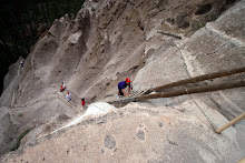
Artifacts like Bandolier reflect a building history dating from 1150 until the mid 1500s, when the Ancestral Pueblo people relocated and left their structures for the elements to reclaim. Luckily there remains enough to transform us to another time and culture. What is especially exciting are the regularly arranged holes in the side of the volcanic tuff cliff-face that reveal where the joists and rafters were supported. Each regular sequence of holes delineate the width of a particular volume (about10-15 feet maximum is my guess) and how many volumes are stacked – sometimes two and sometimes three, always sharing constructed walls. These are certainly among this continent’s earliest urban communities.
These groups of holes also reveal that these dwelling cubes were probably not much taller than about 7’ – 8’. That, along with the floor area tells us that living quarters were tight. And there are many instances where the soft volcanic tuff wall, providing one edge to the dwelling, was carved out to expand living space. While this cliff has natural cavities it is clear that many were expanded, or made anew, to accommodate habitation. What is really remarkable is the size of some of these “caves”. One we looked into was large enough for only 3-4 people, sitting upright, and around a fire (as evidenced by a blackened ceiling). That’s close, and most other dugouts were about the same size or smaller. In addition, some of these carved out volumes had remnants of decorative applications, still visible.
There are other decorations faintly visible on the cliff walls that are either applied (some sort of colored paste) or carved into the cliff-face. We could discern numerous petroglyphs - simple geometric patterns, un-representative though certainly man-made forms, and easily recognisable natural images such as a birds and faces - http://swcenter.fortlewis.edu/inventory/BandRock.htm. As if these aren’t fascinating enough, they occur at locations that were clearly within the living volume, as evidenced by the structural sequence of holes, but also above where those holes indicate a roof, meaning a less-personal gesture that would be visible to others – either tribesmen or enemies. By the way, Pueblo entrances are through the roof, making it very risky for an enemy to enter the structure.
It is often these types of ruins are attributed to both the “Anasazi” and “Pueblo” - at least within my limited knowledge. We encountered a volunteer park agent, around 80 years old, hiking the remains, who offered to answer any questions we had. When asked why one of these names became the other she informed us that "Pueblo" was the name accepted by the inhabitants but "Anasazi" was the name given by the Navajo people, meaning “enemy”. Very telling….
In addition to the cliff dwellings there is also present a crescent-shaped settlement artifact (referred to as Tyuonyi Pueblo) on relatively flat ground where foundations still remain. The crescent foundation is typically 3-to-6 rooms deep without any visible openings between the volumes. Our volunteer ranger informs us that these forms are the foundation volumes and were used for storage, accessed from the rooms above, which commonly rose to 3 stories, encompasing about 400 rooms total. These original structures were also accessed from the roof, making them more secure. The general community of about 100 inhabitants used the open space formed by this 3-story structure communally, and an included sub-grade kiva (covered, recessed cylinder with fireplace to one side) was used for more formal ceremonies. All together these structures form a very rich artifact hinting at a culture that moved on 500 years ago, but whose spiritual presence is still very palpable.
Avery has been very patient to let me take my time here but we are expected back at Roger’s, where Mary Ann is hosting a dinner gathering to celebrate David Taylor’s new photographic book. The party is low-key and we are able to meet those responsible for this beautiful document: Publishers Darius Himes and David Skolkin of Santa Fe’s Radius Books (http://radiusbooks.org), Hannah Frieser, of New York, one of the essayists for the book and, of course David and colleague Stephanie. The evening includes a discussion of the current immigration debate but ultimately concludes with a lively enumeration on which cartoon characters worked for either of Hanna Barbara, Looney Tunes, or the Rocky and Bullwinkle group. Heady stuff….but we have a travel day tomorrow so off to bed.


No comments:
Post a Comment